
Introduzione
This manual provides essential instructions for the setup, operation, maintenance, and troubleshooting of your Lowrance iFinder Expedition C Plus Waterproof Hiking GPS. Designed for outdoor navigation, this 16-channel handheld GPS unit features a color display, electronic compass, barometric altimeter, and MP3 player capabilities. Please read this manual thoroughly to ensure proper use and to maximize the performance of your device.
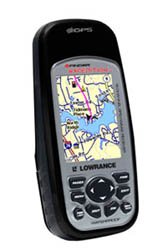
Image of the Lowrance iFinder Expedition C Plus handheld GPS unit, showcasing its color display and button layout.
Impostare
- Installazione della batteria: Open the battery compartment cover on the back of the unit. Insert the required batteries (not included) according to the polarity indicators. Close the cover securely to maintain the waterproof seal.
- Memory Card (MMC/SD) Installation: Locate the memory card slot. Insert the provided MMC/SD memory card, ensuring it is correctly oriented. This card is essential for storing additional maps and data.
- Accensione iniziale: Press and hold the power button until the device screen illuminates. Follow any on-screen prompts for initial setup, such as language selection and time zone.
- MapCreate USA Topo Software Installation: For custom, high-detail mapmaking, install the exclusive MapCreate USA Topo mapping software on your personal computer. Use the provided MMC/SD card reader with a USB connector to transfer maps to your device.
Istruzioni per l'uso
Navigazione di base
- Acquisizione del segnale GPS: For optimal performance, use the device outdoors with a clear view of the sky. The 16-channel GPS receiver will automatically acquire satellite signals.
- Mappa Viewin: Use the directional pad to pan across the map. Zoom in and out using the dedicated zoom buttons. The 2.83-inch diagonal color TFT display with 320 x 240 resolution provides clear map details.
- Waypoint Creation: Mark your current location as a waypoint by pressing the 'Mark' button. You can name and save these points for future reference.
Funzionalità avanzate
- Scout Mode: Activate 'Scout Mode' to mark area perimeters and create custom borders on your map. This is useful for defining hunting grounds, property lines, or exploration areas.
- Bussola elettronica: The built-in electronic compass provides accurate heading information even when stationary. Calibrate the compass periodically as instructed on-screen.
- Altimetro barometrico: The integrated barometric altimeter provides precise altitude readings and can track changes in atmospheric pressure, useful for weather forecasting.
- Lettore mp3: The device includes MP3 player capabilities. Load your favorite audio files onto the MMC/SD card to enjoy music during your expeditions.
- Microfono: Utilize the built-in microphone for voice notes or other audio recordings.
Manutenzione
- Pulizia: Pulisci il dispositivo con un panno morbido eamp panno. Evitare detergenti abrasivi o solventi che potrebbero danneggiare lo schermo o casing.
- Cura impermeabile: While the iFinder Expedition C Plus is waterproof, ensure all port covers and the battery compartment are securely closed before exposure to water. Do not submerge the device beyond its rated depth or for extended periods.
- Magazzinaggio: Quando non si utilizza il dispositivo per lunghi periodi, rimuovere le batterie per evitare perdite. Conservare il dispositivo in un luogo fresco e asciutto, lontano dalla luce solare diretta e da temperature estreme.
- Aggiornamenti software: Controllare periodicamente il Lowrance websito per gli aggiornamenti del firmware per garantire prestazioni ottimali e accesso a nuove funzionalità.
Risoluzione dei problemi
- Il dispositivo non si accende:
- Controllare l'orientamento delle batterie e assicurarsi che siano nuove.
- Assicurarsi che il coperchio del vano batteria sia completamente chiuso.
- Il GPS non acquisisce il segnale:
- Spostarsi in un'area aperta con una chiara view del cielo.
- Attendere alcuni minuti affinché il dispositivo acquisisca i satelliti.
- Screen Issues (Dim/Unresponsive):
- Regola le impostazioni della retroilluminazione.
- Perform a soft reset (refer to the device's on-screen menu for instructions).
- Map Data Not Displaying:
- Ensure the MMC/SD card is properly inserted.
- Verify that map files are correctly loaded onto the memory card using MapCreate USA Topo software.
Specifiche
| Caratteristica | Dettaglio |
|---|---|
| Numero di modello | 112-87 |
| Marca | Bassarenza |
| Canali GPS | 16 canali |
| Tipo di visualizzazione | Color TFT with white LED backlight |
| Dimensioni dello schermo | 2.83 pollici (diagonale) |
| Risoluzione dello schermo | 320 x 240 pixel |
| Dimensioni (L x A x P) | 5.6 x 2.5 x 1.2 pollici (14.2 x 6.35 x 3.05 cm) |
| Peso | 8.7 ounces (0.25 kg) / 1.11 kg (shipping weight) |
| Input dell'interfaccia umana | Microfono |
| Supporto per schede di memoria | MMC / SD |
| Codice UPC | 042194528304 |
Informazioni sulla garanzia
Warranty details for the Lowrance iFinder Expedition C Plus are typically included with the product packaging or available on the official Lowrance website. Please refer to these resources for specific terms, conditions, and registration procedures.
Supporto
For further assistance, technical support, or to download the latest software updates, please visit the official Lowrance website. You may also find FAQs and additional resources there to help you with your iFinder Expedition C Plus GPS unit.